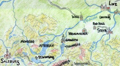
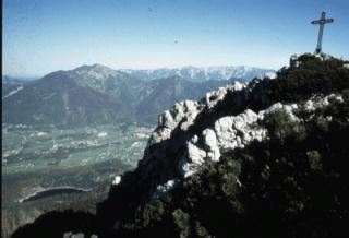
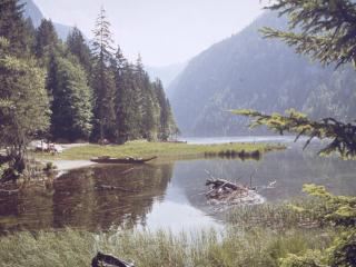
The 'Estate of the Salt District', a vast expanse of forested landscape to the east of Salzburg whose mountainous peaks and melancholy lakes exist in a delicate balance. Within its depths are the great salt mines which bring the prince-archbishops of Salzburg their immense wealth and power. Literally meaning "the place of good salt," the Archbishop fiercly protects the region, even going so far as to allow no foreigners within the district for fear that they try to steal the precious dust. Most of the mountains are rounded limestone with many natural caverns and steep, winding paths. The Traun river ('river of dreams') is the largest among the many streams which traverse the Salzkammergut (which stretches from Salzburg all the way to the Innviertel). Rafts bear all the salt and salt-laden rocks across the lakes, and eventually down the Traun river to the Danube. No large towns populate the district, and the dazzling sparkle of its beautiful lakes and majestic crags are reflected in the ancient magics which permeate the region.
This is the largest and most famous river, or at least the most plied, of the vast Salzkammergut. Flowing out of the largest lake in the district, the Attersee, this river at first foams white and green as it cascades through several tremendous gorges, making the Traun unnavigable. But soon the waters plunge over the beautiful Traunfall and reach down to the village of Lambach. Downstream from this village its waters are more placid, and the river becomes navigable all the way to the Danube.
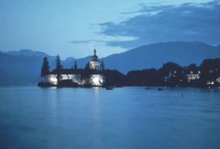
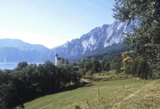
The deepest lake (627 feet) in all of Austria, its western bank is part of the great salt route leading from Hallstatt in the south to Gmünden and Lambach. A narrow, long lake, its northern shore is the site of Gmünden, while in the east limestone cliffs rise up and out of the lake. The Rotelspitze, a great golden peak, and the Traunstein are two mountains which domintate the eastern sky, overlooking the waters of theTraunsee.
 A pretty village with chestnut trees built
on the beaches of the chill waters of the Traunsee. It serves as the port
for workers bearing their bags of salt on barges across the dark waters
of the lake, where they unload their prize and head north on foot for the
nearby hamlet of Lambach (only 7 miles away). Also north of the village
lies a valley into the Innviertel, dotted with numerous lime trees.
A river flows out the lake and north to meet with the waters of the Traun
only 4 miles away, but its rocky bed flows swift and dangerously, foaming
green and white, and is not navigable.
A pretty village with chestnut trees built
on the beaches of the chill waters of the Traunsee. It serves as the port
for workers bearing their bags of salt on barges across the dark waters
of the lake, where they unload their prize and head north on foot for the
nearby hamlet of Lambach (only 7 miles away). Also north of the village
lies a valley into the Innviertel, dotted with numerous lime trees.
A river flows out the lake and north to meet with the waters of the Traun
only 4 miles away, but its rocky bed flows swift and dangerously, foaming
green and white, and is not navigable.
A mountain along the north shore of the Traunsee, called the "sleeping Greek" by locals, who claim to see a form of a sleeping man in the sillhoutte of the range. It can only be discerned on certain days of the year, and since the death of Emperor Frederick Barbarosa, some claim that he lies buried within a chamber in the hill, surrounded by holy knights, waiting to rise up and reunite the Empire in the last days.
This hamlet along the north bank of the Traun is a transfer point for salt brought in sacks from Hallstatt. The salt is carried overland from the Attersee to this village, where it is then loaded into boats and shipped downriver to Wien, Linz, and eventually Bohemia (upstream the river isn't navigable).
The Abbey of Stift
Lambach is also the site of the Benedictine Abbey of Stift, founded in the 11th Century. Romanesque paintings adorn the chancery beneath each of the two towers of the Abbey, with beautiful renditions of the magi, wise-men adoring Jesus, and His life. Linz an-der-Donau lies only 32 miles downriver.
The largest lake in the Salzkammergut, and the source ot the Traun river. To the east, a great bare slope plunges into the waters, while the rest of the banks of the Attersee are marked by steeply wooded shoreline. The nearest parts of the lake lie only 23 miles east of Salzburg. Unfortuantely the Traun river is not navigable between the lake and Lambach, due to many dangerous rapids and gorges. This lake is 10 x 2 miles, and is often plieed by flat rafts carrying salt.
 A watering place in the heart of the Salzkammergut,
in densely wooded mountains. It is located just southeast of the edge of
the Attersee, and south of the Traunsee, inside a loop of waters formed
by the Traun and Ischl rivers. Locals claim the waters here have mystical
healing properties, as they are particularly clear and cool (by modern standards
they would also be considered somewhat acidic).
A watering place in the heart of the Salzkammergut,
in densely wooded mountains. It is located just southeast of the edge of
the Attersee, and south of the Traunsee, inside a loop of waters formed
by the Traun and Ischl rivers. Locals claim the waters here have mystical
healing properties, as they are particularly clear and cool (by modern standards
they would also be considered somewhat acidic).
This village is located at the northwestern end of Lake St-Wolfgang, and is the easternmost fortified outpost of the Archbishop within the Salzkammergut. The Attersee lies only a few miles to the east, and Salzburg a mere 19 miles to the west. The waters of lake Wolfgang are frequently plied by small boats, as a second village named St. Wolfgang lies on the far bank of the lake.
This tiny town stands on a rocky spur on the east shore of the lake of the same name (across the lake from the village of St. Gilgen). Legend has it the Bishop of Regensberg, canonized in 1052, came to the shores of this lake to seek solitude, and the church which stands here bearing his name is the site of freqent pilgrimiges for the folk of nearby Salzburg.
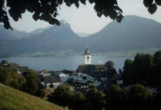
St. Wolfgang
A village on a foothill of the Dachstein Massif, which rises slowly to the South. Named for the lake Hallstattersee , whose dark waters lap at the village, the town is built on very narrow and steep slopes, such that festivals here often proceed on boats to avoid the tiring climbs. Salt mining goes on in neighboring mountain-sides, and this is perhaps the most salt-rich site in all of Europe. The Chapel of St. Michael dominates the humble town, a humble grey stone building with a small cemetary. Numerous salt pens refine the brine brought from the hillsides. Salzburg lies 47 miles to the West.
The tombs of ancient peoples who once lived here (the Celts) have been found in the sides of some of the mountains, and it is often a concern whether to give the salt-preserved bodies discovered within the mountians proper Christian burials.
This town is the capital of the Salzkammergut, built at the juncture of the two rivers which form the upper branches of the Traun river. Situated in a small valley and framed by mountains from the west to east, it is surrounded by two picturesque lakes, the Altauseersee and Grundlesee, and offers a spectacular view of the Dachstein to the south. Salt marshes and mines surround the town. The waters of the nearby Altauseersee are rich in sulphur and purported to have medicinal value.
 A lake lined with lime-trees, in a crescent
shape (hence its name), at the foot of the cliffs of the Drachenwand and
the Schafberg. A Benedictine abbey was founded here in 748 by Duke Odilono
of Bavaria, and villagers have a unique tradition of plying its waters with
Einbaum boats (similar to canoes) cut from a single tree. A chapel for the
villagers stands on a bluff over the lake. Named 'Moon-lake' by the Romans,
its waters are somewhat warmer than the other lakes, and peasants claim
this is so because the moon spirit blesses it because her lover drowned
in it. It is rather small compared to the other lakes of the Salt District,
only about 5 x 1 miles in dimension.
A lake lined with lime-trees, in a crescent
shape (hence its name), at the foot of the cliffs of the Drachenwand and
the Schafberg. A Benedictine abbey was founded here in 748 by Duke Odilono
of Bavaria, and villagers have a unique tradition of plying its waters with
Einbaum boats (similar to canoes) cut from a single tree. A chapel for the
villagers stands on a bluff over the lake. Named 'Moon-lake' by the Romans,
its waters are somewhat warmer than the other lakes, and peasants claim
this is so because the moon spirit blesses it because her lover drowned
in it. It is rather small compared to the other lakes of the Salt District,
only about 5 x 1 miles in dimension.
 A small lake at the western foot
of the Totes Giberge (high mountains in the easternmost reaches of the Salt
District). One of the mountains looming over this lake's fragile waters
is called the 'Fist', named for its unusual silhouette, and cradled in a
ledge somewhere along its treacherous cliffs lies a magical cave called
"the Watchman's Grotto," perhaps a hint of the ancestral might
of the aged Salzkammergut (see the adventure summary The
Watchman's Grotto).
A small lake at the western foot
of the Totes Giberge (high mountains in the easternmost reaches of the Salt
District). One of the mountains looming over this lake's fragile waters
is called the 'Fist', named for its unusual silhouette, and cradled in a
ledge somewhere along its treacherous cliffs lies a magical cave called
"the Watchman's Grotto," perhaps a hint of the ancestral might
of the aged Salzkammergut (see the adventure summary The
Watchman's Grotto).
This page last modified on 2/8/98.
Comments to madirishman@mad-irishman.net
Return to the Rabenstein home page