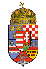
The Kingdom of Hungary
 The Kingdom of Hungary was converted to a Christian land only under King Steven in 1003 AD. German and Italian influence are quite strong, but so too is the traditional emnity between them and the Magyars. A struggle between the new feudal system and Magyar nomadic traditions is raging, and woe to those who find themselves caught up within it. The Kingdom can be divided into two regions based on geography. The first is the great plain (the Alfold), which dominates the Kindgom's center, and remains a vast untamed wilderness. The more densely populated western region is called Transdanubia, and consists of rolling hills extending from the last spurs of the Alps. Here lies Albia Regia (called Szekesfehervar), where the Queen was crowned. The seat of the Kingdom and of its Church was Esztergom. The mighty Danube river serves as the border between the two geographical regions.
- The Great Plain (The Alfold)
- Climate
- Physical Appearance
- Villages
- Organization
- Transdanubia
- Rabenstein's Knowledge of Hungary
- Kobol-Weiler
- Nyiregyhaza
- Sopron (Agram)
- The Amber Road
- Lake Balaton
- Pannonhalma Abbey
- Szekesfehervar
- Bukk Mountains and Matra Mountains
The Great Plain (The Alfold)
This is a large, flat, alluvial flatland, covered in grassland and marshes, never rising to a height of above 600 ft. sealevel. Because of the great number of winding rivers, floods can leave vast regions of standing waters which develop into standing marshes. The large basin is completely surrounded by Mountains...the Dinaric and Carpathian Alps, as well as the Transylvanian and Dalmatian Foothills. The Tisza, Koros, Maros, and Szamos are the main water-courses in the Plain. They are also often a refuge for hunters and fishers, and useful for hiding from the Tartars or other predators.
Villages are scattered across the plain, harvesting grains, fruits, andeven vineyards (for white wine). Sugarbeets, wheat, apricots, apples arewidely grown, but the dominant herb is Paprika, which can be found in almost every Magyar dish. Cattle are herded in vast numbers, as well as pigs, sheep, and horses, and they are driven to market to the south each summer.
Climate
The Plain averages 71 to 75 degrees in the summer months, though it is warmer to the west, and 24 to 31 degrees in the Winter months. Often these temperatures are more extreme in the wide-open stretches of the Plain. Severe thunderstorms often occur in the summer, 20 to 30 times, or up to 40 nearer to Dalmatia. The snows begin in November, and cover much of the ground until sometime in March, for 25-50 days at a time.
Summers are characterized by 70% sunshine, though winters only have 20%.
Physical Appearance
Wild sunflowers dot the vast plain, along with the paprika. The ground is often moist and muddy as a result of the moisture, but shifting sands crack and dry the Plain under the blistering summer sun. The Hungarian earth-rat, reed-wolf, and striped mouse are unique to the Alfold. Further, black-roots, giant beetles, turtles, and vultures are commonly found.
Villages
Because of the shortage of stone and timber on the plain, most of the houses are one story, built of adobe mud, thatch, and reeds. Shifting sands from the steady winds make permanent settlement quite difficult, and to this day, many of the denizens of the Alfold migrate as nomadic tribes. Such groups plant a pole to mark the settlement of a new place.
Many villagers craft wicker-baskets and home-spun carpets. Villages are called 'Weiler', 'Hameau', and 'Szeg' (a Magyar term), and are generally a small group of houses of the same architecture. They are joint- family settlements.
Organization
In the 11th Century, these familial villages were organized according to the heads of the villages. They serve as border guard representatives of the king and are only allowed to move if the land's supplies are exhausted.
Pastures are tended within boundaries, and foreign goods are rare, only the ruling class of towns being able to afford them. Bartering is the common exchange, and no craftsmen exist. Peasants weave, spin, make earthenware pottery, grow vegetables, using hoes, and breed cattle, pigs, sheep, horses, and even pottery.
Transdanubia
The region west of the Great Plain, including the eastern spurs of the Alps and the Mecek and Villany Mountains in the south. Though hilly, it is also known as the 'little plain'. Willow-laden and rich in tributaries to the Danube river, it has prevailing east-to-west winds and winter blizzards. Beeches, oaks, chestnuts, and pine-tree forests dominate the forest-alluvial soil. It is the most densely populated and ancient part of Hungary. Apple, plum, nut, and vineyards dot the landscapes and characterize the villages.
Rabenstein's Knowledge of Hungary
Through 1206, Rabenstein has had quite limited interaction with the Kingdom of Hungary, particularly the expansive Alfold. Nevertheless, the Bjornaer Capra has gleaned much from his time with the shaman Tibor, and some other information has been garnered, and is presented below.
Kobol-Weiler
A small village southeast of the Neusiedler See. Capra has spent considerable time with the village shaman, Tibor. The village is founded near an alder tree than Tibor planted when the site was chosen years ago.
Nyiregyhaza
A cluster of hamlets on the Alfold, spread-out over sandy soil which grows sunflowers, potatoes, as well as orchards of plums and apples. The Tisza River and wine-growing valley of Tokaj lies only 25 miles northwest. The villagers seem to intertwine christianity with old pagan traditions, and a misunderstanding nearly led to the stoning of an expedition from Rabenstein.
Sopron (Agram)
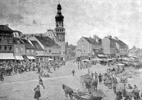 Known as Agram in German,the seat of Sopron county is the site of the westernmost Hungarian diocese and the nearest Hungarian town to Rabenstein, built on the foot of a spur of the Alps (really a continuation of the Styrian foothills). Its almond-shaped fortified walls are being constructed by the Magyars, and dangerous Besenyo archers are known to defend the settlement. The town is dominated by an 183-foot tall belfry with a cylindrical base, which rises from a modern fort standing atop the ruins of the original Roman settlement.
The town has recently beeen designated crown property, and is attracting many Jews due to its expanding privileges as a trading center.
The Amber Road
This ancient Roman highway ran from Italy to the Baltic. Similarly, the Silk road ran from East to West to China.
Lake Balaton
Narrow, shallow, and warm (78 degrees in summer!), this lake is the largest in Europe, but only about 11 feet deep on average because of steady evaporation which matches the in-flow. The southern shore is extremely shallow, and waves from the steady wind have built up a fine sandy beach, but the north coast is more reedy and irregular. The Zala river, which flows out of the Styrian foothills, feeds the lake, entering at the western tip. Long, hot summers here (where the temperature regularly reaches 90 degrees) from May to September are contrasted with cold winters where the lake freezes solid. The Keszthely Mountains dominate the Northwest corner of the lake. It is suspected that the Covenant Valcum (of the Transylvanian Tribunal) lies somewhere near the vicinity of this lake, but its precise location has not been determined yet.
Pannonhalma Abbey
The Benedictine Order founded this monastery in the 10th Century under the protective arm of Prince Geza. It is one of the wealthiest monasteries in all of Hungary, lying on the northern slopes of the Mecsek. Its Romanesque church (built in the 11th Century) houses an extensive library and the Abbey possesses the original Coronation Robe of St. Stephen, made of Bissus silk on the Greek island of Kyros. Red Marble Columns flank the main doorway, with a statue of St. Stephen flanking the library door. The pride of the Abbey is a codice written on lambskin, which is the constant work of the tenant monks. It currently has over 1100 pages and continues to grow. Legends suggest that St. Martin was born in the 4th Century at the site of the Abbey, which stands on St. Martin's Hill with a commanding view of the rolling landscape about it.
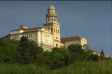
Pannonhalma Abbey
Lassitor of Criamon spent several seasons here investigating the fate of Rabenstein's original Roman garrison, and befriended one of the monks here, Brother Szilard. He discovered that Roman legionnaires are entombed within the hill, their tombstones marked with Latin and heiroglyphics (the place was called 'Sand Hill' by the Romans).
Szekesfehervar
Also called Alba Regia, this town serves as the royal seat where the kings of Hungary are coronated (and many are later buried). The royal palace also stands here.
Bukk Mountains and Matra Mountains
These large rolling hills in the Northern Carpathians are densely forested with oaks. Beech woods still remain on the colder, northern slopes, with pinewoods struggling along rocky areas. The mountaintops never exceed 40 degrees, even in the summer. Some peat-moss fens lie in the valleys of these mountains, but no standing water can be found. Villagers in the north take part in an abundant fur trade, and the settlements are not nomadic like those in the nearby Alfold. The Hungarian boar is unique to the wildlife here.
The Russians Cynric Ex Miscellanea, Brother Meshach, Tatyana, and Piotr crossed these mountains along with Lassitor of Rabenstein en route to Mondsagen Covenant in 1205 (see the adventure summary The Sailors of Mabanogia).
Thanks to Roland Hesz for some minor corrections.
This page last modified on 11/30/98.
Comments to madirishman@mad-irishman.net
Return
to the Rabenstein home page